Old Maps of Lincoln County, Wyoming
Explore 561 old maps of Lincoln County, spanning from 1909 to today. These high-resolution historic maps reveal how streets, neighborhoods, landmarks, and natural features evolved over time — perfect for genealogy, metal detecting, research, and local history exploration.
What you can do with these maps:
- See how Lincoln County changed over time: Compare historical maps to modern-day views to trace roads, homesites, rail lines & more.
- View detailed metadata: Each map includes creators, publishers, year, scale, and archive source.
- Overlay maps with satellite & LiDAR: Visualize the past alongside modern tools to explore terrain & human change.
- Trusted historical sources: Maps sourced from the USGS, Library of Congress, and other archives.
- Access maps your way: View online, download high-res files, or order prints for personal or research use.
Start exploring old maps of Lincoln County to uncover forgotten places, hidden landmarks, and the deep history beneath your feet.
Lincoln County, WY maps
(561)- 1909 Map of Montpelier, 1957 Print
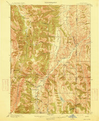
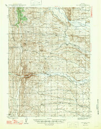
 1909 Montpelier1957 Print · USGSBear Lake County at the turn of the century shows a landscape defined by the arrival of the Oregon Short Line RR and early irrigation. Researchers can trace the original footprints of Montpelier and Paris or locate the historic Hot Springs Turnpike along the lake's eastern shore.
 - 1911 Map of Montpelier
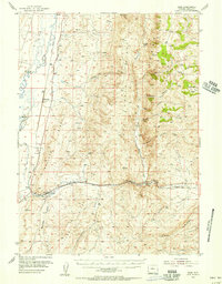
 1911 Montpelier1911 Print · USGSThe Bear Lake Valley at the start of the twentieth century was a vital rail and ranching corridor. Trace the Oregon Short Line RR through Montpelier and Paris, or locate early lakeside settlements like Fish Haven and St Charles.3 unique versions available
 - 1912 Map of Randolph
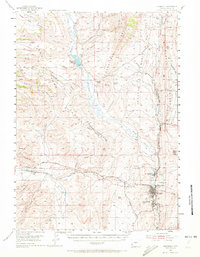
 1912 Randolph1912 Print · USGSThe high valley ranching country of the Utah-Wyoming border is captured here in the early twentieth century. Genealogists and historians can trace family land holdings such as Rex Ranch or Sixmile Ranch and find old routes like the Ogden Road.3 unique versions available
 - 1915 Map of Freedom
 1915 Freedom1915 Print · USGSThe Idaho-Wyoming border comes alive in this survey of the high mountain ranges and irrigated valleys during the early twentieth century. Researchers can trace the path of the Lander Cutoff and locate early community landmarks like the Freedom School or the Old Salt Works.3 unique versions available
 - 1915 Map of Crow Creek
 1915 Crow Creek1915 Print · USGSThe high-desert ranching and salt industries of the Idaho-Wyoming border are captured here just before World War I. Researchers can locate early family homesteads like Cozzens Ranch and Books Ranch, or trace the operations at the Old Salt Works.3 unique versions available
 - 1921 Map of Afton
 1921 Afton1921 Print · USGSStar Valley and the high Wyoming backcountry are captured here in the early twenties, showing the region's early ranching and forestry roots. Researchers can locate early schools like Muddy String School, isolated outposts like Moffat Ranch, and forest service sites including Corral Creek Ranger Sta.
 - 1931 Map of Jackson, 1961 Print
 1931 Jackson1961 Print · USGSJackson and the upper Snake River canyon are documented here in the early thirties, showcasing a wilderness era of ranching and forestry. Researchers can trace early outposts like Browns Ranch or locate family history at the Etna Cem and Johnny Counts Flat.
 - 1932 Map of Irwin
 1932 Irwin1932 Print · USGSThe Snake River corridor and the high mountain basins of eastern Idaho are captured here in the early 1930s. Researchers can trace early river crossings like Edwards Ferry or find small-community landmarks like Rainy Dale and Pumpkin Center Sch.2 unique versions available
 - 1935 Map of Irwin
 1935 Irwin1935 Print · USGSThe Idaho-Wyoming borderlands are captured here in the 1930s as the river economy and mountain ranching defined the region. Researchers can trace the early road networks and rural institutions from Edwards Ferry to local schools like Fidelity Sch and Blowout Sch.3 unique versions available
 - 1935 Map of Jackson
 1935 Jackson1935 Print · USGSThe high valleys of the Teton and Gros Ventre ranges are captured here in the mid-thirties, showing the early infrastructure of the upper Snake River region. Researchers can locate early schools and ranching outposts like Porcupine Sch, Browns Ranch, and the Jackson Mine.2 unique versions available
 - 1936 Map of Cokeville
 1936 Cokeville1936 Print · USGSWestern Wyoming in the mid-1930s reveals a landscape where pioneer history and rail infrastructure meet. Trace the routes of the Oregon Trail and Dempsey Trail past remote schools like Upper Hams Fork Sch and the Fontenelle Ranger Sta.
 - 1942 Map of Cokeville
 1942 Cokeville1942 Print · USGSWestern Wyoming migration routes are frozen in time on this survey of Lincoln County in the late thirties. Genealogists and historians can trace the physical paths of the Oregon Trail, find the Upper Hams Fork Sch, and locate remote outposts like Smiths Fork Guard Station.3 unique versions available
 - 1945 Map of Fort Hill, 1970 Print
 1945 Fort Hill1970 Print · USGSLincoln County ranching and water history come alive in this mid-century survey of the high Wyoming plains. Researchers can locate established homesteads like Herschler Ranch and trace the vital irrigation paths of the La Barge Canal.2 unique versions available
 - 1947 Map of Fort Hill
 1947 Fort Hill1947 Print · USGSThe high ranchlands of western Wyoming are captured in the late 1940s, showing the early infrastructure of Lincoln County. Genealogists and historians can locate family landmarks like the Facenelli Ranch, Herschler Ranch, and the prominent Fort Hill.
 - 1954 Map of Sage, 1956 Print
 1954 Sage1956 Print · USGSLincoln County ranching and rail life are at the forefront during the mid-fifties as the Union Pacific tracks thread through the Bear River valley. Genealogists can trace small settlements like Leefe and Beckwith or locate family landmarks in Bulldog Hollow and Nugget Canyon.2 unique versions available
 - 1954 Map of Ogden, 1967 Print
 1954 Ogden1967 Print · USGSThe northern Utah corridor and Wyoming borderlands are captured here in the mid-1950s, showing the region's transition from mountain wilderness to settled valleys. Researchers can trace historic institutions like Utah State University or locate vanished points like Church Butte Station and the Trappist Monastery.3 unique versions available
 - 1954 Map of Kemmerer, 1972 Print
 1954 Kemmerer1972 Print · USGSLincoln County mining and transportation corridors come alive in the mid-1950s as coal operations and railroads reshape the high desert. Genealogists and historians can trace the Oregon Trail (Cutoff) alongside local coal heritage at Frontier and the Elkol Strip Mine.2 unique versions available
 - 1955 Map of Driggs, 1967 Print
 1955 Driggs1967 Print · USGSEastern Idaho and Western Wyoming appear at a mid-century crossroads as the river valleys were fully settled and the high peaks protected. Genealogists and researchers can trace the rail towns of Rexburg and Driggs or follow the Snake River from Irwin to the Palisades Reservoir.3 unique versions available
 - 1955 Map of Preston, 1968 Print
 1955 Preston1968 Print · USGSSoutheast Idaho and western Wyoming are shown in detail during the mid-fifties, from the high Bear River Range to the Green River Basin. Genealogists and collectors can trace the Union Pacific RR through historic towns like Preston, Montpelier, and Afton.3 unique versions available
 - 1958 Map of Driggs
 1958 Driggs1958 Print · USGSThe high Teton peaks and Snake River valleys are captured here in the mid-fifties, showing the region's agricultural and wilderness boundaries. Researchers can trace the Union Pacific rail corridor through Rexburg or locate early settlements like Clementsville and Tetonia.2 unique versions available
 - 1958 Map of Ogden
 1958 Ogden1958 Print · USGSNorthern Utah and southwestern Wyoming are captured here during a period of steady growth and military expansion. You can trace the Union Pacific rail lines and early road networks connecting Ogden and Logan to Bear Lake and Evanston.
 - 1958 Map of Preston
 1958 Preston1958 Print · USGSThe high valleys of the Idaho and Wyoming borderlands are captured here in the late fifties, showcasing a landscape of mountain ranching and phosphate mining. Genealogists and historians can locate early settlements like Chesterfield and Bedford or trace the Union Pacific rail lines serving Cokeville.2 unique versions available
 - 1960 Map of Ogden
 1960 Ogden1960 Print · USGSIn the mid-1950s, this region of the American West balanced military expansion with frontier history along the Union Pacific RR. Genealogists and historians can trace old settlements like Fort Bridger, the residential growth of Washington Terrace, and industrial sites from the Hill AFB complex to the coal mines of Kemmerer.
 - 1962 Map of Driggs
 1962 Driggs1962 Print · USGSThe Idaho-Wyoming borderlands are captured here in the early sixties, showing the peaks and valleys of the northern Rockies. Genealogists and historians can trace rail lines like the Union Pacific RR and isolated outposts like the National Elk Refuge or the Fort Hall Indian Reservation.
 - 1962 Map of Preston
 1962 Preston1962 Print · USGSSoutheast Idaho and the Wyoming borderlands are captured here in the early sixties, a time of thriving agricultural valleys and mountain ranching. Researchers can trace the Union Pacific rail lines and find legacy settlements like Montpelier, Afton, and Preston.
Showing maps 1-25 of 561
Top cities of Lincoln County
- Kemmerer historical maps
- Afton historical maps
- Star Valley Ranch historical maps
- Alpine historical maps
- Diamondville historical maps
- Cokeville historical maps
See more
Frequently asked questions
- What are the different types of historical maps available for Lincoln County?
- What is the oldest map of Lincoln County?
- Where can I purchase historical maps of Lincoln County for my home or office?
- Where can I download high-res historical maps of Lincoln County?
- Are there historical topographic maps available for Lincoln County?
- Is there historical aerial imagery available for Lincoln County?
- Where are historical maps of Lincoln County sourced from?