1990s Maps of Lincoln County, Wyoming
Explore 8 historic maps of Lincoln County from the 1990s. These maps offer a rare glimpse into what life looked like during the 1990s — showing old roads, neighborhoods, homes, and landmarks that have changed or disappeared over time.
Whether you're researching your family's past, planning a metal detecting trip, or studying how Lincoln County's landscape evolved across the 1990s, these high-resolution maps are a powerful tool for exploring the history of this region.
- Focus on a specific era: All maps on this page are from the 1990s, giving you a focused view of this time period.
- See what’s changed: Compare century-old streets, trails, and buildings to today's modern landscape using overlays and satellite layers.
- Research with precision: Use these maps for genealogy, historical research, land use analysis, or educational projects.
- View, download, or print: Maps are fully viewable online in high resolution, and can be downloaded or printed for your own records.
Start exploring Lincoln County's history through authentic maps from the 1990s. This is your window into the past.
Lincoln County, WY maps
(8)- 1996 Map of Munger Mountain, 1998 Print
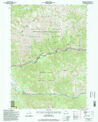
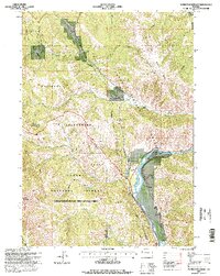 1996 Munger Mountain1998 Print · USGSThe Snake River corridor and the Teton and Lincoln county lines are captured here in the late nineties. Researchers can locate Astoria Mineral Hot Springs, the settlement of Hoback, and remote landmarks like the Rock Quarry or Red Top Meadows.
 - 1996 Map of Observation Peak, 1998 Print
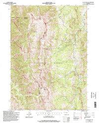
 1996 Observation Peak1998 Print · USGSHigh Wyoming wilderness along the Snake River Range is captured in the 1990s as it appeared before modern developments. Researchers can trace remote mountain routes through North Indian Creek Pass and landmark summits like Observation Peak and Indian Peak.2 unique versions available
 - 1996 Map of Pickle Pass, 1998 Print
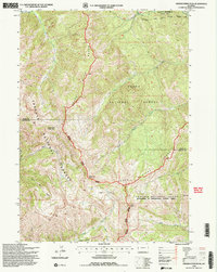
 1996 Pickle Pass1998 Print · USGSLincoln County’s high mountain passes and national forest boundaries are captured here in the mid-1990s. Researchers can trace remote backcountry infrastructure like the STEWART TRAIL, the Hunting Camp, and water sources such as Mc Cain Spring and the Water Trough.2 unique versions available
 - 1996 Map of Hoback Peak, 1998 Print
 1996 Hoback Peak1998 Print · USGSHigh alpine ridges and remote Wyoming forest lands define this region during the mid-1990s. Trace old wilderness routes like the High Line Trail and locate landmarks such as the Hunting Camp, Bare Hole, and the peaks of the Upper Hoback Canyon.
 - 1996 Map of Ferry Peak, 1998 Print
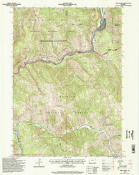
 1996 Ferry Peak1998 Print · USGSLincoln County in the mid-1990s is captured at the confluence of the Snake and Greys Rivers during a period of modern forest management. Trace topographic details from Ferry Peak to Little Jenny Lake, or locate specific sites like the Greys River Bridge Gaging Station and the Rock Quarry.2 unique versions available
 - 1996 Map of Clause Peak, 1998 Print
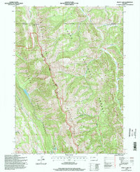
 1996 Clause Peak1998 Print · USGSHigh wilderness terrain in the late 1990s shows where the Sublette and Lincoln county lines meet within the Teton National Forest. Researchers can trace the drainages of Sandy Marshall Creek and Clause Creek while orienting by peaks like Ramshorn Peak.
 - 1996 Map of Pine Creek, 1998 Print
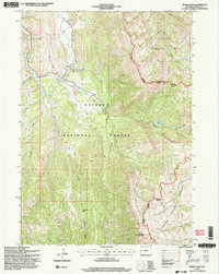
 1996 Pine Creek1998 Print · USGSThe Grand Canyon of the Snake River and the Greys River confluence are the focal points of this mid-nineties Forest Service revision. Trace the river-side network of campsites like Station Creek Camp or locate high-country landmarks including Elk Mountain.
 - 1996 Map of Bailey Lake, 1998 Print
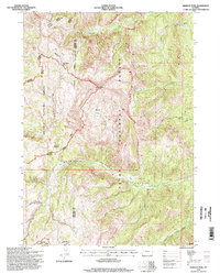
 1996 Bailey Lake1998 Print · USGSThe Lincoln County high country is shown in the mid-1990s as a complex of forest districts and mountain drainages. Researchers can trace remote landmarks like the Rimrock Home, the Pow Wow Electronic Point Site, and alpine waters including Bailey Lake.
End of results
Showing maps 1-8 of 8
Top cities of Lincoln County
- Kemmerer historical maps
- Afton historical maps
- Star Valley Ranch historical maps
- Alpine historical maps
- Diamondville historical maps
- Cokeville historical maps
See more
Frequently asked questions
- What are the different types of historical maps available for Lincoln County?
- What is the oldest map of Lincoln County?
- Where can I purchase historical maps of Lincoln County for my home or office?
- Where can I download high-res historical maps of Lincoln County?
- Are there historical topographic maps available for Lincoln County?
- Is there historical aerial imagery available for Lincoln County?
- Where are historical maps of Lincoln County sourced from?