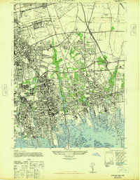
1947 Map of Freeport
USGS Topo · Published 1947About this map
Roosevelt Field and Mitchell Field anchor the northern landscape of this post-war Nassau County survey, reflecting the region's mid-century identity as a hub for early aviation. The coastal marshlands around Freeport and Baldwin are intricately mapped, showing the complex network of islands like Cuba Island and Middle Island before modern shoreline stabilization. Inland, the rapid transition from agrarian estates to suburban residential blocks is evident in Garden City and Hempstead.
Find a feature on this map
96 named features on this map. Tap any name to fly to it.
Don’t see what you’re looking for? This feature index may not catch every label — zoom into the map to look around manually.
Map Details
Editions of this 1947 Freeport Map
This is the sole edition of this map. No revisions or reprints were ever made.
Other maps of this area

1897 · Hempstead
USGS Topo · 1:62,500

1897 · Oyster Bay
USGS Topo · 1:62,500

1898 · Hempstead
USGS Topo · 1:62,500

1898 · Oyster Bay
USGS Topo · 1:62,500

1899 · Hempstead
USGS Topo · 1:62,500

1900 · Oyster Bay
USGS Topo · 1:62,500

1901 · Babylon
USGS Topo · 1:62,500

1901 · Northport
USGS Topo · 1:62,500

1903 · Babylon
USGS Topo · 1:62,500

1903 · Northport
USGS Topo · 1:62,500