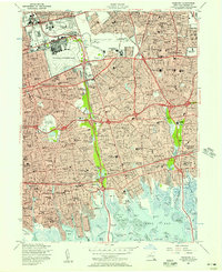
1955 Map of Freeport
USGS Topo · Published 1957About this map
Mitchell Air Force Base and its adjacent Santini Sub Base anchor the northern landscape of central Nassau County, surrounded by a burgeoning network of mid-century suburban developments. This mid-1950s survey captures a pivotal moment of expansion as post-war housing tracts like Levittown and East Meadow fill the spaces between established hubs such as Hempstead and Freeport. The era's reliance on car culture and rail is evident in the layout of the Southern State Pkwy and the Long Island RR, while the sprawling grounds of Roosevelt Raceway and Hofstra College mark significant land use.
Find a feature on this map
96 named features on this map. Tap any name to fly to it.
Don’t see what you’re looking for? This feature index may not catch every label — zoom into the map to look around manually.
Map Details
Editions of this 1955 Freeport Map
This is the sole edition of this map. No revisions or reprints were ever made.
Other maps of this area

1897 · Hempstead
USGS Topo · 1:62,500

1897 · Oyster Bay
USGS Topo · 1:62,500

1898 · Hempstead
USGS Topo · 1:62,500

1898 · Oyster Bay
USGS Topo · 1:62,500

1899 · Hempstead
USGS Topo · 1:62,500

1900 · Oyster Bay
USGS Topo · 1:62,500

1901 · Babylon
USGS Topo · 1:62,500

1901 · Northport
USGS Topo · 1:62,500

1903 · Babylon
USGS Topo · 1:62,500

1903 · Northport
USGS Topo · 1:62,500