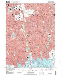
1994 Map of Freeport
USGS Topo · Published 2000About this map
The dense residential corridors of central Nassau County are defined here by a sophisticated network of parkways and coastal wetlands in the mid-1990s. Heavy infrastructure like the Southern State Parkway and Wantagh State Parkway carves through established communities from Hempstead to Freeport. This era shows the region as a fully realized suburban landscape, where large-scale civic sites like Eisenhower County Park and the historic Roosevelt Raceway occupy significant acreage alongside academic hubs like Nassau Community College. Along the southern margin, the map reveals the intricate transition from suburban streets to the salt marshes and channels of Merrick Bay and Baldwin Bay. These tidal areas, including Fighting Island and Pettit Marsh, stand in sharp contrast to the inland grid, illustrating the proximity of these South Shore towns to the protected waters of the Great South Bay system.
Find a feature on this map
83 named features on this map. Tap any name to fly to it.
Don’t see what you’re looking for? This feature index may not catch every label — zoom into the map to look around manually.
Map Details
Editions of this 1994 Freeport Map
This is the sole edition of this map. No revisions or reprints were ever made.
Other maps of this area

1897 · Hempstead
USGS Topo · 1:62,500

1897 · Oyster Bay
USGS Topo · 1:62,500

1898 · Hempstead
USGS Topo · 1:62,500

1898 · Oyster Bay
USGS Topo · 1:62,500

1899 · Hempstead
USGS Topo · 1:62,500

1900 · Oyster Bay
USGS Topo · 1:62,500

1901 · Babylon
USGS Topo · 1:62,500

1901 · Northport
USGS Topo · 1:62,500

1903 · Babylon
USGS Topo · 1:62,500

1903 · Northport
USGS Topo · 1:62,500