
1957 Map of Fremont
USGS Topo · Published 1957About this map
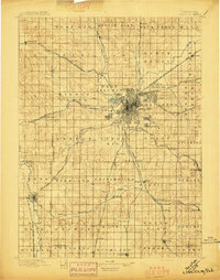
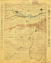
The Elkhorn River and Platte River valleys define this mid-1950s landscape, illustrating a region deeply tied to its fertile bottomlands and river-fed transport corridors. Compiled by the Army Map Service, the survey shows a dense network of agrarian settlements and rural infrastructure before the widespread consolidation of the late 20th century. Local landmarks such as the Ordnance Plant and Offutt Air Force Base reflect the era's significant military footprint in the region. Transportation is dominated by major rail lines, including the Union Pacific and Illinois Central, which link towns like West Point and Stanton. Education and social life are anchored by numerous small schools and churches, such as Beulah School and the church at Saint Bernard. The map also captures several early recreational areas, including the Dead Timber Recreation Grounds and Lake Quinnebaugh Recreation Grounds, providing a look at mid-century leisure spaces.
Find a feature on this map
172 named features on this map. Tap any name to fly to it.
Don’t see what you’re looking for? This feature index may not catch every label — zoom into the map to look around manually.
Map Details
Editions of this 1957 Fremont Map
This is the sole edition of this map. No revisions or reprints were ever made.
Other maps of this area

1893 · Omaha
USGS Topo · 1:62,500

1893 · Fremont
USGS Topo · 1:125,000

1896 · Stromsburg
USGS Topo · 1:125,000

1896 · Fremont
USGS Topo · 1:125,000
1897 · Lincoln
USGS Topo · 1:125,000

1898 · York
USGS Topo · 1:125,000

1898 · Grand Island
USGS Topo · 1:125,000

1899 · Wahoo
USGS Topo · 1:125,000
1899 · David City
USGS Topo · 1:125,000

1899 · St. Paul
USGS Topo · 1:125,000