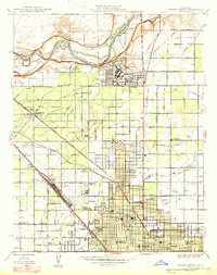
1947 Map of Fresno North
USGS Topo · Published 1947About this map
The San Joaquin River forms the natural northern boundary of this survey, where the Circle M Ranch sits just across the Madera Co Fresno Co line. In the years following World War II, the landscape north of Fresno reveals a transition from the agricultural grid of the San Joaquin Valley to emerging military and institutional centers. Significant wartime infrastructure is evident at Camp Pinedale and the adjacent Army Air Forces Depot, while the academic footprint of Fresno State College and Fresno High Sch anchors the northern city districts. The map documents an extensive irrigation network, including the Bullard Canal and Enterprise Canal, which sustained the region's orchards and fields between the major rail lines of the Southern Pacific Railroad and the Atchison Topeka and Santa Fe.
Find a feature on this map
58 named features on this map. Tap any name to fly to it.
Don’t see what you’re looking for? This feature index may not catch every label — zoom into the map to look around manually.
Map Details
Editions of this 1947 Fresno North Map
This is the sole edition of this map. No revisions or reprints were ever made.
Other maps of this area

1921 · Bullard
USGS Topo · 1:31,680

1922 · Lanes Bridge
USGS Topo · 1:31,680

1922 · Friant
USGS Topo · 1:31,680

1922 · Gregg
USGS Topo · 1:31,680

1923 · Kearney Park
USGS Topo · 1:31,680

1923 · Malaga
USGS Topo · 1:31,680

1923 · Herndon
USGS Topo · 1:31,680

1923 · Fresno
USGS Topo · 1:31,680

1923 · Clovis
USGS Topo · 1:31,680

1923 · Bullard
USGS Topo · 1:31,680