
1923 Map of Malaga
USGS Topo · Published 1923About this map
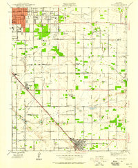
The County Fair Grounds Auto Speedway stands as a prominent landmark on the outskirts of Fresno, marking an era of early 20th-century entertainment and regional gathering. This landscape is a meticulously gridded agricultural hub, where the Fresno Canal and Fowler Switch Canal provide the vital irrigation required for the intensive orchard and vineyard operations of the San Joaquin Valley. Industrial sites like the Mattei Packing Co Plant and the nearby Experimental Farm reflect the sophisticated development of the local fruit industry.
Find a feature on this map
61 named features on this map. Tap any name to fly to it.
Don’t see what you’re looking for? This feature index may not catch every label — zoom into the map to look around manually.
Map Details
Editions of this 1923 Malaga Map
This is the sole edition of this map. No revisions or reprints were ever made.
Other maps of this area

1921 · Bullard
USGS Topo · 1:31,680

1922 · Round Mountain
USGS Topo · 1:31,680

1923 · Fresno
USGS Topo · 1:31,680

1923 · Clovis
USGS Topo · 1:31,680

1923 · Sanger
USGS Topo · 1:31,680

1923 · Bullard
USGS Topo · 1:31,680

1924 · Selma
USGS Topo · 1:31,680

1924 · Conejo
USGS Topo · 1:31,680

1925 · Caruthers
USGS Topo · 1:31,680
1946 · Malaga
USGS Topo · 1:24,000