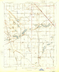
1924 Map of Selma
USGS Topo · Published 1924About this map
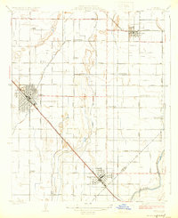
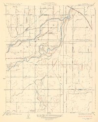
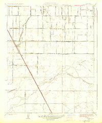
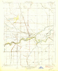
The agrarian landscape of the San Joaquin Valley is defined here by the diagonal strike of the Southern Pacific railroad, which anchors the major hubs of Selma and Kingsburg. This 1920s-era survey reveals a densely gridded network of rural schools and cultural centers, including the Danish Church, Swedish Mission, and facilities like Fruitvale School and Walnut School. The infrastructure of irrigation is central to the area's development, evidenced by the Mill Ditch, Kingsburg Canal, and Selma Colony Ditch drawing from the Kings River in the southeast corner. These waterways supported the expansion of orchards and vineyards between the growing towns and the smaller settlement of Parlier to the north. Boundary lines for the Fresno Co Tulare Co border cross the southern reaches, marking the transition between these productive agricultural counties.
Find a feature on this map
38 named features on this map. Tap any name to fly to it.
Don’t see what you’re looking for? This feature index may not catch every label — zoom into the map to look around manually.
Map Details
Editions of this 1924 Selma Map
This is the sole edition of this map. No revisions or reprints were ever made.
Other maps of this area

1922 · Trimmer
USGS Topo · 1:96,000

1923 · Malaga
USGS Topo · 1:31,680
1923 · Wahtoke
USGS Topo · 1:31,680
1923 · Sanger
USGS Topo · 1:31,680
1924 · Reedley
USGS Topo · 1:31,680
1924 · Conejo
USGS Topo · 1:31,680

1924 · Dinuba
USGS Topo · 1:125,000
1926 · Burris Park
USGS Topo · 1:31,680
1927 · Traver
USGS Topo · 1:31,680
1927 · Laton
USGS Topo · 1:31,680