
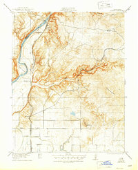
1922 Map of Friant
USGS Topo · Published 1922About this map
Friant stands at the edge of the foothills where the San Joaquin River emerges from the high country, serving as a critical junction for the Southern Pacific railroad in the early twentieth century. The landscape is defined by the transition from the rugged slopes of Owens Mountain down to the organized agricultural infrastructure of the Enterprise Canal. Local industry and rural life are evidenced by the Fresno Copper Mine and several scattered educational outposts like Pollasky School and Millerton School. Further south, the map details the rail-driven transit network through Gordon Siding and El Prado, while the winding Little Dry Creek and Gates Lake illustrate the natural drainage of the Fresno County interior before mid-century water management transformed the valley.
Find a feature on this map
22 named features on this map. Tap any name to fly to it.
Don’t see what you’re looking for? This feature index may not catch every label — zoom into the map to look around manually.
Map Details
Editions of this 1922 Friant Map
2 editions found
Other maps of this area

1912 · Mariposa
USGS Topo · 1:125,000

1916 · Sulphur Springs
USGS Topo · 1:24,000

1919 · Sulphur Springs
USGS Topo · 1:31,680

1919 · Little Table Mountain
USGS Topo · 1:31,680

1921 · Bullard
USGS Topo · 1:31,680

1922 · Round Mountain
USGS Topo · 1:31,680

1922 · Lanes Bridge
USGS Topo · 1:31,680

1923 · Academy
USGS Topo · 1:31,680

1923 · Clovis
USGS Topo · 1:31,680

1923 · Bullard
USGS Topo · 1:31,680