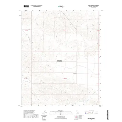
2018 Map of Fried Liver Wash
USGS Topo · Published 2018About this map
Joshua Tree National Park encompasses a significant portion of this high-desert landscape, where the rugged peaks of the Pinto Mountains meet the vast Pinto Basin. The terrain is defined by dry drainage systems that trace the movement of seasonal water through the Mojave Desert, including the winding Fried Liver Wash and Washington Wash. These natural conduits connect the northern ridges with the wide alluvial plains of Pleasant Valley and Music Valley. To the southwest, the Hexie Mountains rise sharply, creating a stark contrast with the broad basins below. The map captures an era of preserved wilderness, detailing the complex network of canyons like Wilson Canyon and the distinct desert washes that shaped the hydrology and passage through this interior section of the park before modern environmental shifts.
Find a feature on this map
17 named features on this map. Tap any name to fly to it.
Don’t see what you’re looking for? This feature index may not catch every label — zoom into the map to look around manually.
Map Details
Editions of this 2018 Fried Liver Wash Map
This is the sole edition of this map. No revisions or reprints were ever made.
Other maps of this area

1942 · Amboy
USGS Topo · 1:250,000

1943 · Amboy
USGS Topo · 1:250,000

1943 · Pinkham Well
USGS Topo · 1:62,500

1944 · Pinkham Well
USGS Topo · 1:62,500

1944 · Pinyon Well
USGS Topo · 1:62,500

1947 · Santa Ana
USGS Topo · 1:250,000

1949 · Santa Ana
USGS Topo · 1:250,000

1953 · San Bernardino
USGS Topo · 1:250,000

1954 · Salton Sea
USGS Topo · 1:250,000

1954 · Needles
USGS Topo · 1:250,000