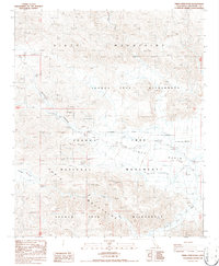
1986 Map of Fried Liver Wash
USGS Topo · Published 1986About this map
Paymaster Mine and the Golden Bell Mine sit within a high desert landscape defined by the convergence of the Pinto Mountains and the Hexie Mountains. This 1980s-era topographical record highlights a region transitioning into protected status, showing the intersection of historic extraction and conservation. The map details the drainage patterns of Fried Liver Wash as it descends toward the Pinto Basin, providing a precise look at the arid terrain before significant modern park boundary shifts. Prospectors and desert historians can identify isolated workings such as the Eldorado Mine and Golden Bee Mine, which are scattered throughout the Joshua Tree National Monument and the designated Joshua Tree Wilderness. From Pleasant Valley to the depths of Wilson Canyon, the map preserves the exact locations of these remote sites.
Find a feature on this map
16 named features on this map. Tap any name to fly to it.
Don’t see what you’re looking for? This feature index may not catch every label — zoom into the map to look around manually.
Map Details
Editions of this 1986 Fried Liver Wash Map
This is the sole edition of this map. No revisions or reprints were ever made.
Other maps of this area

1942 · Amboy
USGS Topo · 1:250,000

1943 · Amboy
USGS Topo · 1:250,000

1943 · Pinkham Well
USGS Topo · 1:62,500

1944 · Pinkham Well
USGS Topo · 1:62,500

1944 · Pinyon Well
USGS Topo · 1:62,500

1947 · Santa Ana
USGS Topo · 1:250,000

1949 · Santa Ana
USGS Topo · 1:250,000

1953 · San Bernardino
USGS Topo · 1:250,000

1954 · Salton Sea
USGS Topo · 1:250,000

1954 · Needles
USGS Topo · 1:250,000