
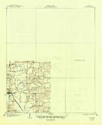
1929 Map of Frisco
USGS Topo · Published 1929About this map
The Elm Fork Trinity River landscape in the mid-1920s is defined by a dense network of rural school districts and small creek-side settlements before the expansion of North Texas reservoirs. The town of Lewisville stands as a primary hub, served by the Missouri Kansas and Texas railroad and the Dallas-Denton Electric line. This preliminary survey, which utilizes early aerial photography from the Army Air Corps, captures the area's transition into a more interconnected region while maintaining its agrarian character. Local education is central to the community fabric, evidenced by numerous named schoolhouses like Hackberry Sch, Lake Sch, and Round Grove Sch that dot the countryside. Near the confluence of Hickory Creek and the main river fork, landmarks such as Wink Bridge and the small settlement of Rector provide specific points of interest for those studying the early 20th-century geography of Denton and Collin counties.
Find a feature on this map
22 named features on this map. Tap any name to fly to it.
Don’t see what you’re looking for? This feature index may not catch every label — zoom into the map to look around manually.
Map Details
Editions of this 1929 Frisco Map
2 editions found
Other maps of this area

1891 · Dallas
USGS Topo · 1:125,000

1893 · Dallas
USGS Topo · 1:125,000

1894 · Fort Worth
USGS Topo · 1:125,000

1925 · Mc Kinney 3-c
USGS Topo · 1:48,000

1925 · Dallas 2-b
USGS Topo · 1:48,000

1929 · McKinney
USGS Topo · 1:62,500

1931 · Carrollton
USGS Topo · 1:62,500

1931 · Grapevine
USGS Topo · 1:62,500

1954 · Dallas
USGS Topo · 1:250,000

1954 · Sherman
USGS Topo · 1:250,000