
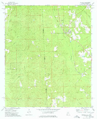
1974 Map of Fruitdale
USGS Topo · Published 1977About this map
The Illinois Central Gulf railroad tracks run northwest through the heart of Fruitdale, a community defined by its timbered landscape and scattered family landmarks in the 1970s. The settlement's social fabric is visible through the High Sch and nearby spiritual centers like the Church of the Brethren and Epworth Ch. To the south, the landscape becomes increasingly rural, dominated by the Kurtz State Forest and a series of drainage networks including Tarkiln Creek and Byrd Creek. Small family and community cemeteries like Macedonia Cem, Grimes Cem, and Williams Cem are found throughout the area, providing valuable points of reference for genealogists. The eastern boundary is shaped by the Escatawpa River, which separates the community from the neighboring settlement of Escatawpa. Evidence of local industry appears in the form of scattered Gas Wells and a Drill Hole located west of the main town center.
Find a feature on this map
27 named features on this map. Tap any name to fly to it.
Don’t see what you’re looking for? This feature index may not catch every label — zoom into the map to look around manually.
Map Details
Editions of this 1974 Fruitdale Map
2 editions found
Other maps of this area

1942 · Deer Park
USGS Topo · 1:62,500

1943 · Deer Park
USGS Topo · 1:62,500

1953 · Hattiesburg
USGS Topo · 1:250,000

1958 · Hattiesburg
USGS Topo · 1:250,000

1964 · Knobtown
USGS Topo · 1:24,000

1964 · Clark
USGS Topo · 1:24,000

1972 · Leakesville
USGS Topo · 1:24,000

1974 · Chatom
USGS Topo · 1:24,000

1974 · State Line
USGS Topo · 1:24,000

1974 · Vinegar Bend
USGS Topo · 1:24,000