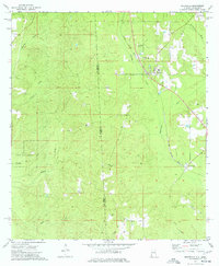
1974 Map of Fruitdale
USGS Topo · Published 1977About this map
The Illinois Central Gulf railroad serves as the industrial spine for this borderland corridor between Alabama and Mississippi during the mid-1970s. The settlement of Fruitdale is the primary hub, anchored by its High Sch and the Church of the Brethren. To the west, the landscape transitions into the preserved timberlands of the Kurtz State Forest, while the winding Escatawpa River defines the eastern geography. This survey captures a rural landscape where family and community history is etched into the terrain through numerous burial grounds, including Macedonia Cem, Grimes Cem, and Williams Cem. Local industry is evidenced by scattered resource extraction points such as a Drill Hole and several Gas Well sites, highlighting the mix of traditional forestry and emerging energy interests that shaped Washington County during this era.
Find a feature on this map
25 named features on this map. Tap any name to fly to it.
Don’t see what you’re looking for? This feature index may not catch every label — zoom into the map to look around manually.
Map Details
Editions of this 1974 Fruitdale Map
2 editions found
Other maps of this area

1942 · Deer Park
USGS Topo · 1:62,500

1943 · Deer Park
USGS Topo · 1:62,500

1953 · Hattiesburg
USGS Topo · 1:250,000

1958 · Hattiesburg
USGS Topo · 1:250,000

1964 · Knobtown
USGS Topo · 1:24,000

1964 · Clark
USGS Topo · 1:24,000

1972 · Leakesville
USGS Topo · 1:24,000

1974 · Fruitdale
USGS Topo · 1:24,000

1974 · Chatom
USGS Topo · 1:24,000

1974 · State Line
USGS Topo · 1:24,000