
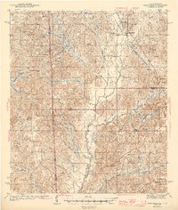
1943 Map of Deer Park
USGS Topo · Published 1943About this map
The Escatawpa River winds southward through the center of this 1942 survey, defining a landscape of piney woods and creek bottoms along the Alabama and Mississippi border. Small settlements and industrial camps are scattered across the terrain, connected by the Mississippi and Alabama RR which cuts through the northeastern corner near Deer Park. The presence of Stalworth Camp and Turners Store suggests a rural economy tied to timber and local trade during the early war years.
Find a feature on this map
60 named features on this map. Tap any name to fly to it.
Don’t see what you’re looking for? This feature index may not catch every label — zoom into the map to look around manually.
Map Details
Editions of this 1943 Deer Park Map
2 editions found
Other maps of this area

1941 · Creola
USGS Topo · 1:62,500

1941 · Lucedale
USGS Topo · 1:62,500

1942 · Deer Park
USGS Topo · 1:62,500

1942 · Wilmer
USGS Topo · 1:62,500

1943 · Lucedale
USGS Topo · 1:62,500

1943 · Creola
USGS Topo · 1:62,500

1943 · Citronelle
USGS Topo · 1:62,500

1943 · McIntosh
USGS Topo · 1:62,500

1944 · McIntosh
USGS Topo · 1:62,500

1944 · Wilmer
USGS Topo · 1:62,500