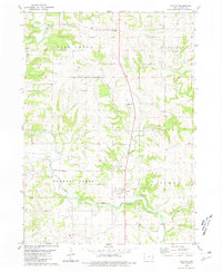
1980 Map of Fulton
USGS Topo · Published 1981About this map
The North Fork Maquoketa River meanders across this Jackson County landscape, anchored by the village of Fulton. This 1980 survey captures the agricultural heart of eastern Iowa, where the river's path is monitored by a Gaging Station and the land is divided into the townships of Otter Creek, Richland, Farmers Creek, and Perry.
Find a feature on this map
21 named features on this map. Tap any name to fly to it.
Don’t see what you’re looking for? This feature index may not catch every label — zoom into the map to look around manually.
Map Details
Editions of this 1980 Fulton Map
This is the sole edition of this map. No revisions or reprints were ever made.
Other maps of this area

1891 · Maquoketa
USGS Topo · 1:62,500

1891 · Baldwin
USGS Topo · 1:62,500

1901 · Peosta
USGS Topo · 1:125,000

1935 · East Dubuque
USGS Topo · 1:62,500

1940 · East Dubuque
USGS Topo · 1:62,500

1959 · Dubuque
USGS Topo · 1:250,000

1961 · Dubuque
USGS Topo · 1:250,000

1962 · Dubuque
USGS Topo · 1:250,000
1962 · La Motte
USGS Topo · 1:24,000

1962 · Zwingle
USGS Topo · 1:24,000