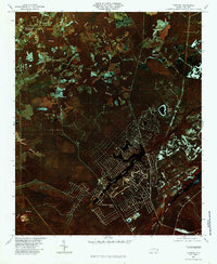
1980 Map of Funston
USGS Topo · Published 1985About this map
Boiling Spring Lakes forms the central hub of this 1980 color infrared orthophotograph, showing a distinctive residential street pattern emerging around the jagged shoreline of Boiling Springs Lake. This coastal Brunswick County landscape is defined by its complex drainage network, where the low-lying terrain is divided by extensive wetlands such as Bell Swamp and Harris Swamp. To the north, the small settlement of Funston sits near the headwaters of Allen Creek, while Brunswick Station anchors the northwestern corner of the quadrangle. The imagery highlights the stark contrast between the dense, wooded swamps like Middle Swamp and the planned development of the lakes region. Notable water bodies including Pretty Pond and the upper reaches of Orton Pond are visible, alongside numerous tributaries like Swain Branch that feed into the larger coastal basins.
Find a feature on this map
15 named features on this map. Tap any name to fly to it.
Don’t see what you’re looking for? This feature index may not catch every label — zoom into the map to look around manually.
Map Details
Editions of this 1980 Funston Map
This is the sole edition of this map. No revisions or reprints were ever made.
Other maps of this area

1942 · Wilmington
USGS Topo · 1:62,500

1943 · Funston
USGS Topo · 1:24,000

1943 · Winnabow
USGS Topo · 1:24,000

1943 · Bolivia
USGS Topo · 1:24,000

1943 · Lockwoods Folly
USGS Topo · 1:24,000

1943 · Lewis Swamp
USGS Topo · 1:24,000

1944 · Bolivia
USGS Topo · 1:31,680

1944 · Winnabow
USGS Topo · 1:31,680

1944 · Lockwoods Folly
USGS Topo · 1:31,680

1944 · Lewis Swamp
USGS Topo · 1:31,680