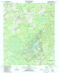
1990 Map of Funston
USGS Topo · Published 1991About this map
Boiling Spring Lakes forms the central residential and geographic heart of this map, characterized by a planned street grid and a network of water bodies including Boiling Spring Lake, Clear Pond, and North Lake. The landscape is defined by the transition from low-lying wetlands such as Harris Swamp and Middle Swamp to the tidal and industrial zones bordering the Cape Fear River. To the southeast, the massive footprint of the Military Ocean Terminal Sunny Point dominates the coastal corridor, adjacent to the sprawling waters of Orton Pond.
Find a feature on this map
32 named features on this map. Tap any name to fly to it.
Don’t see what you’re looking for? This feature index may not catch every label — zoom into the map to look around manually.
Map Details
Editions of this 1990 Funston Map
This is the sole edition of this map. No revisions or reprints were ever made.
Other maps of this area

1942 · Wilmington
USGS Topo · 1:62,500

1943 · Funston
USGS Topo · 1:24,000

1943 · Winnabow
USGS Topo · 1:24,000

1943 · Bolivia
USGS Topo · 1:24,000

1943 · Lockwoods Folly
USGS Topo · 1:24,000

1943 · Lewis Swamp
USGS Topo · 1:24,000

1944 · Bolivia
USGS Topo · 1:31,680

1944 · Winnabow
USGS Topo · 1:31,680

1944 · Lockwoods Folly
USGS Topo · 1:31,680

1944 · Lewis Swamp
USGS Topo · 1:31,680