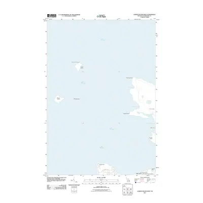
2011 Map of Garden Island West
USGS Topo · Published 2011About this map
Squaw Island Lighthouse stands as a sentinel over the northern waters of Lake Michigan, marking a critical navigation point near the archipelago. This 2011 survey illustrates the intricate coastline of Garden Island and its smaller neighbors, revealing a landscape defined by isolated points and sheltered bays such as Bomways Bay and Ninnegoes Bay. The presence of the Indian Cemetery and Saint James Township Cemetery near the southeastern coast suggests the deep cultural and community roots maintained on these islands.
Find a feature on this map
18 named features on this map. Tap any name to fly to it.
Don’t see what you’re looking for? This feature index may not catch every label — zoom into the map to look around manually.
Map Details
Editions of this 2011 Garden Island West Map
This is the sole edition of this map. No revisions or reprints were ever made.
Other maps of this area

1955 · Hog Island
USGS Topo · 1:62,500

1955 · Cheboygan
USGS Topo · 1:250,000

1956 · Beaver Island
USGS Topo · 1:62,500

1958 · Cheboygan
USGS Topo · 1:250,000
1973 · Point Patterson
USGS Topo · 1:24,000
1980 · Garden Island West
USGS Topo · 1:24,000

1984 · Beaver Island
USGS Topo · 1:100,000

1986 · High Island
USGS Topo · 1:24,000

1986 · Beaver Island North
USGS Topo · 1:24,000
1986 · Hog Island West
USGS Topo · 1:24,000