
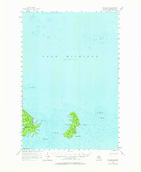
1955 Map of Hog Island
USGS Topo · Published 1958About this map
Hog Island and its surrounding archipelago dominate this mid-century hydrographic survey, illustrating the complex maritime geography of Lake Michigan before modern developments. The land is characterized by the expansive Pigeon River State Forest, which covers both Hog and Garden Island, suggesting a landscape dedicated to timber and conservation. Significant attention is paid to navigational hazards, with soundings and contours defining Mille Coquins Reefs and Fagan Reef to the north. Sheltered waters like Sturgeon Bay and Fisherman Bay provide insight into the natural harbors used by mariners in this portion of the Beaver Island archipelago. The map also captures smaller, distinct landforms such as Hat Island, Shoe Island, and Pismire Island, which serve as vital landmarks in the open water.
Find a feature on this map
24 named features on this map. Tap any name to fly to it.
Don’t see what you’re looking for? This feature index may not catch every label — zoom into the map to look around manually.
Map Details
Editions of this 1955 Hog Island Map
2 editions found
Other maps of this area

1931 · Epoufette SW
USGS Topo · 1:31,680

1931 · Gould City SE
USGS Topo · 1:31,680

1954 · Sault Sainte Marie
USGS Topo · 1:250,000

1955 · Cheboygan
USGS Topo · 1:250,000

1956 · Beaver Island
USGS Topo · 1:62,500

1956 · Sault Sainte Marie
USGS Topo · 1:250,000

1957 · Sault Sainte Marie
USGS Topo · 1:250,000

1958 · Cheboygan
USGS Topo · 1:250,000

1958 · Sault Sainte Marie
USGS Topo · 1:250,000

1958 · Cross Village
USGS Topo · 1:62,500