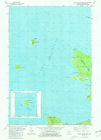
1980 Map of Garden Island West
USGS Topo · Published 1981About this map
Lake Michigan surrounds a cluster of northern islands in this 1980 survey, where remote settlements and the legacy of Great Lakes maritime history intersect. On Squaw Island, an Abandoned Lighthouse marks a previous era of navigation, while Whiskey Island and Trout Island sit isolated in the open waters. Much of the land area is occupied by Garden Island, dominated by the Jordan River State Forest and indented by several protected bays, including Bomways Bay and Indian Harbor. The map reveals the small shoreline settlements of Garden and Graves, along with Indian Cem, reflecting the area's ancestral and cultural heritage. To the south, a portion of Beaver Island shows the village of St James and its Twp Cem, serving as the primary hub for this island chain within St James Township.
Find a feature on this map
26 named features on this map. Tap any name to fly to it.
Don’t see what you’re looking for? This feature index may not catch every label — zoom into the map to look around manually.
Map Details
Editions of this 1980 Garden Island West Map
This is the sole edition of this map. No revisions or reprints were ever made.
Other maps of this area

1955 · Hog Island
USGS Topo · 1:62,500

1955 · Cheboygan
USGS Topo · 1:250,000

1956 · Beaver Island
USGS Topo · 1:62,500

1958 · Cheboygan
USGS Topo · 1:250,000
1973 · Point Patterson
USGS Topo · 1:24,000

1984 · Beaver Island
USGS Topo · 1:100,000

1986 · High Island
USGS Topo · 1:24,000

1986 · Beaver Island North
USGS Topo · 1:24,000
1986 · Hog Island West
USGS Topo · 1:24,000

2011 · Beaver Island North OE E
USGS Topo · 1:24,000