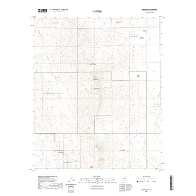
2023 Map of Gardner Peak
USGS Topo · Published 2023About this map
The San Andres Mountains dominate this high-desert landscape in Doña Ana County, where sharp elevation changes define the transition from canyon floors to prominent summits like Gardner Peak and Block Mountain. This modern survey illustrates the intersection of conservation and military use, with a significant portion of the territory falling within the San Andres National Wildlife Refuge and the White Sands Missile Range. Water sources are critical landmarks in this arid environment, evidenced by isolated points such as San Adrecito Spring, Mayberry Spring, and Crawford Spring. The rugged eastern slopes are deeply incised by drainages like Dead Man Canyon and Lost Man Canyon, which feed into Andrecito Creek. Along the southern boundary, Onate Mountain stands near the head of San Andrecito Canyon, highlighting the complex topography that has historically restricted movement through this region.
Find a feature on this map
24 named features on this map. Tap any name to fly to it.
Don’t see what you’re looking for? This feature index may not catch every label — zoom into the map to look around manually.
Map Details
Editions of this 2023 Gardner Peak Map
This is the sole edition of this map. No revisions or reprints were ever made.
Other maps of this area

1916 · Tonuco
USGS Topo · 1:125,000

1916 · Point Of Sands
USGS Topo · 1:125,000

1932 · Tonuco
USGS Topo · 1:125,000

1947 · Point Of Sands 2
USGS Topo · 1:62,500

1947 · Lake Lucero
USGS Topo · 1:62,500

1948 · Bear Peak
USGS Topo · 1:62,500

1948 · Kaylor Mountain
USGS Topo · 1:62,500

1948 · Lake Lucero
USGS Topo · 1:24,000
1950 · Lake Lucero
USGS Topo · 1:24,000

1955 · Las Cruces
USGS Topo · 1:250,000