
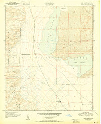
1948 Map of Lake Lucero
USGS Topo · Published 1958About this map
White Sands Proving Grounds dominates this 1940s landscape, illustrating a critical era of military expansion in the New Mexico desert. The sheet captures the intersection of federal land management, showing the White Sands National Monument boundary meeting the San Andres National Wildlife Refuge along the western edge. This area is defined by the harsh hydrology of Lake Lucero and the expansive Alkali Flat, where water is scarce and highly localized. Human presence is minimal and tied to the land's ranching history, evidenced by the Lucero Ranch and a nearby Windmill Water source. To the west, the San Andres Mountains rise sharply, with drainage features like Ash Canyon cutting through the topography. This survey provides a record of the region before further development of the proving grounds fundamentally altered access to these remote desert basins.
Find a feature on this map
12 named features on this map. Tap any name to fly to it.
Don’t see what you’re looking for? This feature index may not catch every label — zoom into the map to look around manually.
Map Details
Editions of this 1948 Lake Lucero Map
This is the sole edition of this map. No revisions or reprints were ever made.
Other maps of this area

1916 · Tonuco
USGS Topo · 1:125,000

1916 · Point Of Sands
USGS Topo · 1:125,000

1932 · Tonuco
USGS Topo · 1:125,000

1947 · Point Of Sands 2
USGS Topo · 1:62,500

1947 · Lake Lucero
USGS Topo · 1:62,500

1948 · Bear Peak
USGS Topo · 1:62,500

1948 · Kaylor Mountain
USGS Topo · 1:62,500

1948 · Lake Lucero SW
USGS Topo · 1:24,000

1948 · Lake Lucero SE
USGS Topo · 1:24,000
1950 · Lake Lucero
USGS Topo · 1:24,000