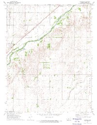
1972 Map of Garfield
USGS Topo · Published 1974About this map
The Arkansas River cuts a diagonal path across this section of southwestern Kansas, serving as the central geographic axis for the small community of Garfield. In the early 1970s, the landscape was a mix of river bottomlands and the rising elevations of Pleasant Ridge and Pleasant Grove. Transport and industry are closely tied to the water, with the Atchison Topeka and Santa Fe railroad tracks paralleling the river's course, passing through the village of Hamburg. Away from the river, the township of Orange is defined by a systematic grid of section lines and the emerging footprint of the energy industry. Numerous Oil Wells and scattered Gravel Pits indicate the extraction economy of Pawnee County during this era, while Pickle Creek drains the southern fields toward the main river valley.
Find a feature on this map
15 named features on this map. Tap any name to fly to it.
Don’t see what you’re looking for? This feature index may not catch every label — zoom into the map to look around manually.
Map Details
Editions of this 1972 Garfield Map
This is the sole edition of this map. No revisions or reprints were ever made.
Other maps of this area

1889 · Larned
USGS Topo · 1:125,000

1889 · Kinsley
USGS Topo · 1:125,000

1891 · Larned
USGS Topo · 1:125,000

1892 · Kinsley
USGS Topo · 1:125,000

1894 · Kinsley
USGS Topo · 1:125,000

1955 · Great Bend
USGS Topo · 1:250,000

1955 · Pratt
USGS Topo · 1:250,000

1957 · Great Bend
USGS Topo · 1:250,000

1958 · Great Bend
USGS Topo · 1:250,000

1959 · Pratt
USGS Topo · 1:250,000