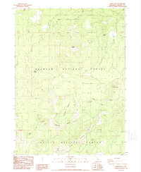
1988 Map of Garner Mountain
USGS Topo · Published 1988About this map
Garner Mtn stands as a prominent landmark within this 1980s survey of the high-elevation boundary where Klamath National Forest meets Shasta National Forest. This section of Siskiyou County is defined by its volcanic and dramatic relief, featuring the sprawling Typhoon Mesa and the distinct volcanic form of Garner Butte. The map documents a high-country landscape essential for water resources, noted by the presence of Tamarack Lake and several critical watering points including Baird Springs and Lost Spring. Of particular interest to industrial historians is the Old Railroad Grade visible in the northeast, a silent reminder of early timber extraction efforts that once penetrated these high ridges. The complex terrain of Typhoon Ridge and Fisk Ridge illustrates the challenging geography that historically dictated transport and land use in this part of Northern California.
Find a feature on this map
16 named features on this map. Tap any name to fly to it.
Don’t see what you’re looking for? This feature index may not catch every label — zoom into the map to look around manually.
Map Details
Editions of this 1988 Garner Mountain Map
This is the sole edition of this map. No revisions or reprints were ever made.
Other maps of this area

1886 · Modoc Lava Bed
USGS Topo · 1:250,000

1892 · Modoc Lava-Bed
USGS Topo · 1:250,000

1932 · Bartle
USGS Topo · 1:96,000

1939 · Bartle
USGS Topo · 1:125,000

1950 · Bray
USGS Topo · 1:62,500

1952 · Medicine Lake
USGS Topo · 1:62,500

1954 · Alturas
USGS Topo · 1:250,000

1958 · Alturas
USGS Topo · 1:250,000

1961 · Hambone
USGS Topo · 1:62,500

1961 · Bartle
USGS Topo · 1:62,500