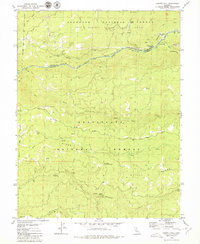
1979 Map of Garnet Hill
USGS Topo · Published 1979About this map
The North Fork Mokelumne River carves a deep boundary between Amador and Calaveras Counties, defining a landscape dominated by timber management and hydroelectric infrastructure. The presence of the Regulatory Canal and various flumes alongside Tiger Creek indicates a highly engineered water system supporting the region. Higher elevations are marked by distinctive peaks such as Garnet Hill and Buck Mtn, while the Salt Springs Ridge overlooks the Salt Springs State Game Refuge to the north.
Find a feature on this map
35 named features on this map. Tap any name to fly to it.
Don’t see what you’re looking for? This feature index may not catch every label — zoom into the map to look around manually.
Map Details
Editions of this 1979 Garnet Hill Map
This is the sole edition of this map. No revisions or reprints were ever made.
Other maps of this area

1889 · Pyramid Peak
USGS Topo · 1:125,000

1891 · Big Trees
USGS Topo · 1:125,000

1891 · Pyramid Peak
USGS Topo · 1:125,000

1894 · Big Trees
USGS Topo · 1:125,000

1895 · Pyramid Peak
USGS Topo · 1:125,000

1896 · Pyramid Peak
USGS Topo · 1:125,000

1897 · Big Trees
USGS Topo · 1:125,000

1901 · Big Trees
USGS Topo · 1:125,000

1947 · Sacramento
USGS Topo · 1:250,000

1948 · Sacramento
USGS Topo · 1:250,000