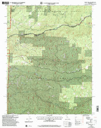
2001 Map of Garnet Hill
USGS Topo · Published 2004About this map
The North Fork Mokelumne River carves a deep boundary between Amador and Calaveras counties, defining a landscape of high ridges and significant water resources. This 2001 revision illustrates the complex topography of the Sierra Nevada foothills, where the Eldorado National Forest meets the Stanislaus National Forest. Resource extraction and land management are evident through the presence of the Moore Mine and a local Quarry, while the Salt Springs State Game Refuge suggests a focus on wildlife conservation in the northern sector. The map details a network of forest roads like Winton Road and Bailey Ridge Road that traverse the rugged elevations between Buck Mountain and Garnet Hill. Scattered settlements such as Walker and specific landmarks like the Gaging Station and various springs provide essential reference points for local history and topography within this timbered region.
Find a feature on this map
30 named features on this map. Tap any name to fly to it.
Don’t see what you’re looking for? This feature index may not catch every label — zoom into the map to look around manually.
Map Details
Editions of this 2001 Garnet Hill Map
This is the sole edition of this map. No revisions or reprints were ever made.
Other maps of this area

1889 · Pyramid Peak
USGS Topo · 1:125,000

1891 · Big Trees
USGS Topo · 1:125,000

1891 · Pyramid Peak
USGS Topo · 1:125,000

1894 · Big Trees
USGS Topo · 1:125,000

1895 · Pyramid Peak
USGS Topo · 1:125,000

1896 · Pyramid Peak
USGS Topo · 1:125,000

1897 · Big Trees
USGS Topo · 1:125,000

1901 · Big Trees
USGS Topo · 1:125,000

1947 · Sacramento
USGS Topo · 1:250,000

1948 · Sacramento
USGS Topo · 1:250,000