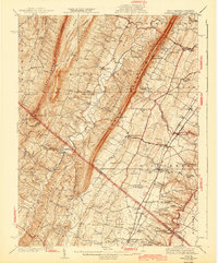
1943 Map of Gerrardstown
USGS Topo · Published 1943About this map
Gerrardstown and the surrounding Berkeley County landscape sit at a geographic crossroads where the valley floor meets the steep rise of North Mountain. This 1943 edition, based on earlier surveys by Hersey Munroe and others, reveals a rural economy shaped by limestone quarries and traditional community centers. The eastern half of the sheet is densely dotted with markers of local heritage, from the Old Stone Ch near Green Spring to the County Home north of Nollville. Notable educational and religious landmarks like Sylvan Retreat School and Tuscarora Church serve as vital anchor points for genealogists tracking family ties in the Shenandoah Valley. The landscape is also defined by historic transit corridors, including the Valley Pike and the Old Braddock Road, which run parallel to the Pennsylvania and Baltimore and Ohio railroads that fueled the region's mid-century growth.
Find a feature on this map
118 named features on this map. Tap any name to fly to it.
Don’t see what you’re looking for? This feature index may not catch every label — zoom into the map to look around manually.
Map Details
Editions of this 1943 Gerrardstown Map
This is the sole edition of this map. No revisions or reprints were ever made.
Other maps of this area

1884 · Harpers Ferry
USGS Topo · 1:125,000

1891 · Harpers Ferry
USGS Topo · 1:125,000

1893 · Harpers Ferry
USGS Topo · 1:125,000

1894 · Winchester
USGS Topo · 1:125,000

1898 · Paw Paw
USGS Topo · 1:62,500

1899 · Hancock
USGS Topo · 1:62,500

1900 · Pawpaw
USGS Topo · 1:62,500

1901 · Hancock
USGS Topo · 1:62,500

1910 · Paw Paw
USGS Topo · 1:62,500

1912 · Williamsport
USGS Topo · 1:62,500