2023 Map of Gilbertsville
USGS Topo · Published 2023About this map
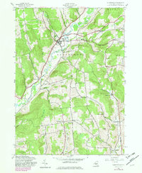
Butternut Creek defines the valley through this portion of Otsego County, where the village of Gilbertsville serves as the primary hub of settlement. The landscape is marked by a network of rural roads that connect smaller hamlets and historical landmarks, such as Unadilla Center and Rootville. For those investigating local history or genealogy, the map identifies several distinct burial grounds, including the Old Churchyard Cem and Brookside Cem near the main village, as well as the more remote Prentiss Cem and Blanchard Cem.
Find a feature on this map
84 named features on this map. Tap any name to fly to it.
Don’t see what you’re looking for? This feature index may not catch every label — zoom into the map to look around manually.
Map Details
Editions of this 2023 Gilbertsville Map
This is the sole edition of this map. No revisions or reprints were ever made.
Historical Maps of Unadilla Through Time
3 maps found