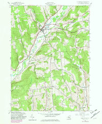
1943 Map of Gilbertsville
USGS Topo · Published 1983About this map
Butternut Creek carves a central path through this Otsego County landscape, anchoring a valley of agricultural settlements and family-named crossroads as they appeared during the early 1940s. The village of Gilbertsville serves as the primary hub, surrounded by smaller communities such as Unadilla Center and Heslops Corner. The map reveals a high density of rural institutions, including one-room schoolhouses like School No 11 and School No 4, alongside several burial grounds such as Brookside Cem and the Prentiss Cem.
Find a feature on this map
44 named features on this map. Tap any name to fly to it.
Don’t see what you’re looking for? This feature index may not catch every label — zoom into the map to look around manually.
Map Details
Editions of this 1943 Gilbertsville Map
2 editions found

Other maps of this area

1910 · Hartwick
USGS Topo · 1:62,500

1910 · New Berlin
USGS Topo · 1:62,500

1912 · New Berlin
USGS Topo · 1:62,500

1912 · Hartwick
USGS Topo · 1:62,500

1915 · Oneonta
USGS Topo · 1:62,500

1915 · Unadilla
USGS Topo · 1:62,500

1918 · Unadilla
USGS Topo · 1:62,500

1918 · Oneonta
USGS Topo · 1:62,500

1943 · Sidney
USGS Topo · 1:24,000

1943 · New Berlin South
USGS Topo · 1:24,000