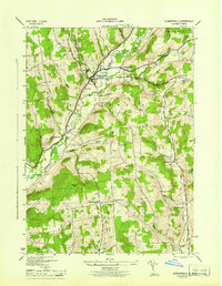
1945 Map of Gilbertsville
USGS Topo · Published 1945About this map
Butternut Creek carves a deep valley through this portion of Otsego County, anchoring a landscape defined by small agricultural hamlets and crossroads. The village of Gilbertsville serves as the primary hub, where the Brookside Cem, Old Cem, and Hollis Cem suggest a long-established local history. The surrounding uplands are dotted with family-named corners such as Heslops Corner, Toll Corner, and Hughston Corners, reflecting a 1940s settlement pattern where rural life centered around local schoolhouses like Townline Sch and Sisson Hill Sch. This mid-century survey, produced by the Tennessee Valley Authority for the War Department, shows a highly developed network of secondary roads and brooks, including Dunderberg Creek and Indian Creek, connecting the townships of Butternuts and Unadilla. The terrain is punctuated by the marshy Black Ash Bog and high points like Filer Hill, illustrating the varied topography of the Unadilla Valley region.
Find a feature on this map
40 named features on this map. Tap any name to fly to it.
Don’t see what you’re looking for? This feature index may not catch every label — zoom into the map to look around manually.
Map Details
Editions of this 1945 Gilbertsville Map
This is the sole edition of this map. No revisions or reprints were ever made.
Other maps of this area

1910 · Hartwick
USGS Topo · 1:62,500

1910 · New Berlin
USGS Topo · 1:62,500

1912 · New Berlin
USGS Topo · 1:62,500

1912 · Hartwick
USGS Topo · 1:62,500

1915 · Oneonta
USGS Topo · 1:62,500

1915 · Unadilla
USGS Topo · 1:62,500

1918 · Unadilla
USGS Topo · 1:62,500

1918 · Oneonta
USGS Topo · 1:62,500

1943 · Sidney
USGS Topo · 1:24,000

1943 · New Berlin South
USGS Topo · 1:24,000