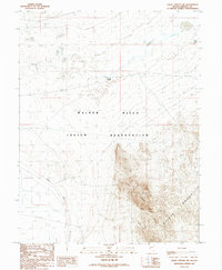
1987 Map of Gillis Canyon NW
USGS Topo · Published 1988About this map
The Walker River Indian Reservation dominates this 1980s landscape in Mineral County, where the transition between high desert peaks and river valley is clearly defined. The Southern Pacific railroad corridor cuts through the southwestern corner, while multiple sections of Old RR Grade elsewhere suggest a complex history of shifting transit routes through this arid terrain. Topography is marked by the stark elevation of the Gillis Range and the Agai Pah Hills, contrasting with the low-lying Alkali Flat. Water management is evident through the presence of an Aqueduct and the remote Double Spring, highlighting the critical nature of resources in this environment. Significant infrastructure including a Telephone Line and a localized Gravel Pit indicate the utility and industry serving this portion of the Walker River basin during the late twentieth century.
Find a feature on this map
11 named features on this map. Tap any name to fly to it.
Don’t see what you’re looking for? This feature index may not catch every label — zoom into the map to look around manually.
Map Details
Editions of this 1987 Gillis Canyon NW Map
This is the sole edition of this map. No revisions or reprints were ever made.
Other maps of this area

1908 · Carson Sink
USGS Topo · 1:250,000

1909 · Hawthorne
USGS Topo · 1:250,000

1910 · Carson Sink
USGS Topo · 1:250,000

1911 · Hawthorne
USGS Topo · 1:250,000

1915 · Hawthorne
USGS Topo · 1:250,000

1948 · Walker Lake
USGS Topo · 1:250,000

1951 · Allen Springs
USGS Topo · 1:62,500

1951 · Weber Reservoir
USGS Topo · 1:62,500

1957 · Walker Lake
USGS Topo · 1:250,000

1957 · Reno
USGS Topo · 1:250,000