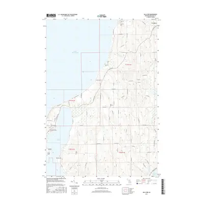
2017 Map of Gills Pier
USGS Topo · Published 2017About this map
Lake Michigan defines the western edge of this Leelanau County peninsula, where several distinct settlements and heritage sites dot the shoreline and interior. The village of Northport sits at the northeastern corner near Grand Traverse Bay, while the community of Leland occupies the southwestern coast, positioned where Lake Leelanau nearly meets the big lake. Between these points, the map records the namesake Gills Pier along with several waterways including Houdek Cr and Roaring Brook.
Find a feature on this map
76 named features on this map. Tap any name to fly to it.
Don’t see what you’re looking for? This feature index may not catch every label — zoom into the map to look around manually.
Map Details
Editions of this 2017 Gills Pier Map
This is the sole edition of this map. No revisions or reprints were ever made.
Other maps of this area

1954 · Traverse City
USGS Topo · 1:250,000

1955 · Cheboygan
USGS Topo · 1:250,000

1957 · Traverse City
USGS Topo · 1:62,500

1957 · Northport
USGS Topo · 1:62,500

1957 · Maple City
USGS Topo · 1:62,500

1958 · Cheboygan
USGS Topo · 1:250,000

1958 · Traverse City
USGS Topo · 1:250,000

1983 · Northport
USGS Topo · 1:25,000

1983 · Omena
USGS Topo · 1:24,000
1983 · Northport NW
USGS Topo · 1:25,000