
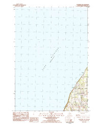
1983 Map of Omena
USGS Topo · Published 1984About this map
The eastern finger of the Leelanau Peninsula is defined here by its relationship with the water, as the land tapers toward Omena Point between Northport Bay and Omena Bay. Small settlements including Omena and Ahgosatown dot the coastline, connected by the rail line of the Leelanau Transit Company. The map shows a landscape of mixed recreation and local industry, featuring the Timber Shores Campground and Shady Trails Camp alongside a Gravel Pit and several small inland water bodies like Mougeys Lake and Ennis Cr.
Find a feature on this map
34 named features on this map. Tap any name to fly to it.
Don’t see what you’re looking for? This feature index may not catch every label — zoom into the map to look around manually.
Map Details
Editions of this 1983 Omena Map
This is the sole edition of this map. No revisions or reprints were ever made.
Other maps of this area

1954 · Central Lake
USGS Topo · 1:62,500

1954 · Traverse City
USGS Topo · 1:250,000

1955 · Cheboygan
USGS Topo · 1:250,000

1957 · Traverse City
USGS Topo · 1:62,500

1957 · Northport
USGS Topo · 1:62,500

1957 · Elk Rapids
USGS Topo · 1:62,500

1958 · Cheboygan
USGS Topo · 1:250,000

1958 · Traverse City
USGS Topo · 1:250,000

1983 · Northport
USGS Topo · 1:25,000
1983 · Northport NW
USGS Topo · 1:25,000