
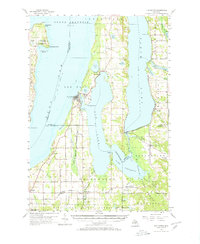
1957 Map of Elk Rapids
USGS Topo · Published 1958About this map
The Peninsula and the eastern shores of Grand Traverse Bay define this mid-century portrait of Michigan's lake country. At the northern tip of the narrow landmass, the Lighthouse at Old Mission Point stands as a sentinel near the historic settlement of Old Mission. The landscape is a complex network of glacial water bodies, where Elk Lake and Torch Lake are linked by the Torch River, creating a continuous waterway that shaped the local timber and tourism industries.
Find a feature on this map
64 named features on this map. Tap any name to fly to it.
Don’t see what you’re looking for? This feature index may not catch every label — zoom into the map to look around manually.
Map Details
Editions of this 1957 Elk Rapids Map
2 editions found
Other maps of this area

1954 · Central Lake
USGS Topo · 1:62,500

1954 · Traverse City
USGS Topo · 1:250,000

1955 · Cheboygan
USGS Topo · 1:250,000

1956 · Mancelona
USGS Topo · 1:62,500

1956 · Kalkaska
USGS Topo · 1:62,500

1956 · Fife Lake
USGS Topo · 1:62,500

1956 · Kingsley
USGS Topo · 1:62,500

1957 · Traverse City
USGS Topo · 1:62,500

1957 · Northport
USGS Topo · 1:62,500

1958 · Cheboygan
USGS Topo · 1:250,000