
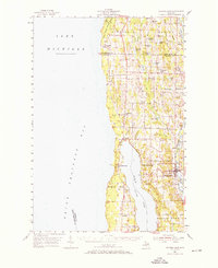
1954 Map of Central Lake
USGS Topo · Published 1955About this map
Torch Lake and the Chain of Lakes dominate this mid-century landscape in northern Michigan, where the narrow strip of land between Grand Traverse Bay and the inland waters defines the region's layout. The settlement of Central Lake serves as a focal point along the shores of Hanley Lake and Intermediate Lake, showing a community deeply integrated with its waterways. Further north, the small hamlets of Norwood, Atwood, and Ellsworth are connected by a network of rural roads that navigate the complex glacial topography. Genealogy researchers will find several well-defined burial grounds including Antrim Cem and Lake View Cem, along with local landmarks like the Greenwood Grange Sch and the Gospel Center Ch. The map also captures a notable piece of forest history with the Lookout Tower (Abandoned) located near the eastern shore of Torch Lake.
Find a feature on this map
51 named features on this map. Tap any name to fly to it.
Don’t see what you’re looking for? This feature index may not catch every label — zoom into the map to look around manually.
Map Details
Editions of this 1954 Central Lake Map
2 editions found
Other maps of this area

1954 · Charlevoix
USGS Topo · 1:62,500

1954 · Traverse City
USGS Topo · 1:250,000

1955 · Cheboygan
USGS Topo · 1:250,000

1956 · Mancelona
USGS Topo · 1:62,500

1957 · Traverse City
USGS Topo · 1:62,500

1957 · Northport
USGS Topo · 1:62,500

1957 · Elk Rapids
USGS Topo · 1:62,500

1958 · Cheboygan
USGS Topo · 1:250,000

1958 · Traverse City
USGS Topo · 1:250,000

1958 · Bayshore
USGS Topo · 1:62,500