
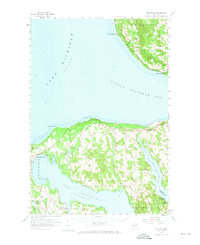
1958 Map of Bayshore
USGS Topo · Published 1959About this map
Little Traverse Bay and the northern reaches of Lake Charlevoix dominate this late-1950s survey of the Michigan shoreline. The landscape is a network of small settlements and rural landmarks, from the coastal village of Bayshore to the inland community at Horton Bay. Transportation is anchored by the Chesapeake and Ohio line, which skirts the northern coast past Big Rock Point and Ninemile Point. For local historians, the map preserves the locations of numerous community hubs, including Greensky Ch, the Grange Hall, and several family-named burial grounds like Dyer Cem and Undine Cem. The presence of the Drive-in Theater near Bayshore and the Pigeon River State Forest to the southeast reflects a mid-century balance of modern recreation and protected timberland. Further south, the ferry crossing at Ironton remains a vital link across the narrow channel connecting the main lake to its southern arm.
Find a feature on this map
52 named features on this map. Tap any name to fly to it.
Don’t see what you’re looking for? This feature index may not catch every label — zoom into the map to look around manually.
Map Details
Editions of this 1958 Bayshore Map
2 editions found
Other maps of this area

1954 · Central Lake
USGS Topo · 1:62,500

1954 · Charlevoix
USGS Topo · 1:62,500

1955 · Cheboygan
USGS Topo · 1:250,000

1958 · Cheboygan
USGS Topo · 1:250,000

1958 · Cross Village
USGS Topo · 1:62,500

1958 · Pellston
USGS Topo · 1:62,500

1958 · Petoskey
USGS Topo · 1:62,500

1961 · Boyne Falls
USGS Topo · 1:62,500

1961 · Boyne City
USGS Topo · 1:62,500

1975 · Petoskey NW
USGS Topo · 1:24,000