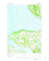
1958 Map of Bayshore
USGS Topo · Published 1973About this map
The coastal landscapes of Lake Michigan and Little Traverse Bay define this 1958 survey, capturing the northern Michigan shoreline before modern expansion. Significant transport corridors like the Chesapeake and Ohio railroad connect the lakeside settlements of Harbor Springs and Bayshore, reflecting a period when rail remained a vital link for the region's industry and tourism. Inland, the map reveals a network of rural communities such as Horton Bay and Ironton, interspersed with local landmarks like Greensky Ch and the North Bay Cem. The presence of the Fivemile Sch (Abandoned) and other country schoolhouses like Murray Sch and Maplewood Sch provides a tangible look at the evolving social geography of Charlevoix and Emmet counties. From the deep waters of Lake Charlevoix to the protected acreage of the Pigeon River State Forest, the sheet documents a balance between small-town settlement and the enduring natural features of the lake country.
Find a feature on this map
45 named features on this map. Tap any name to fly to it.
Don’t see what you’re looking for? This feature index may not catch every label — zoom into the map to look around manually.
Map Details
Editions of this 1958 Bayshore Map
2 editions found
Other maps of this area

1954 · Central Lake
USGS Topo · 1:62,500

1954 · Charlevoix
USGS Topo · 1:62,500

1955 · Cheboygan
USGS Topo · 1:250,000

1958 · Cheboygan
USGS Topo · 1:250,000

1958 · Cross Village
USGS Topo · 1:62,500

1958 · Pellston
USGS Topo · 1:62,500

1958 · Bayshore
USGS Topo · 1:62,500

1958 · Petoskey
USGS Topo · 1:62,500

1961 · Boyne Falls
USGS Topo · 1:62,500

1961 · Boyne City
USGS Topo · 1:62,500