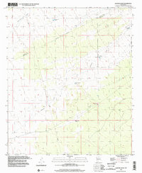
1996 Map of Gilmore Draw
USGS Topo · Published 2002About this map
Hille Ranch sits at the heart of this high-desert landscape on the border of Sierra and Doña Ana counties, illustrating the reliance on isolated water sources for ranching in the late twentieth century. The map details a network of vital infrastructure, including House Pasture Windmill and several catchment basins like Lyons Tank and Sand Hills Tanks, which sustained livestock across the arid terrain.
Find a feature on this map
15 named features on this map. Tap any name to fly to it.
Don’t see what you’re looking for? This feature index may not catch every label — zoom into the map to look around manually.
Map Details
Editions of this 1996 Gilmore Draw Map
This is the sole edition of this map. No revisions or reprints were ever made.
Other maps of this area

1916 · Tonuco
USGS Topo · 1:125,000

1932 · Tonuco
USGS Topo · 1:125,000

1948 · Chicken Well
USGS Topo · 1:62,500

1948 · Bear Peak
USGS Topo · 1:62,500

1948 · San Diego Mountain
USGS Topo · 1:62,500

1948 · Kaylor Mountain
USGS Topo · 1:62,500

1955 · Las Cruces
USGS Topo · 1:250,000

1958 · Las Cruces
USGS Topo · 1:250,000

1981 · Gilmore Draw
USGS Topo · 1:24,000
1981 · Fleck Draw
USGS Topo · 1:24,000