
2011 Map of Girdletree
USGS Topo · Published 2011About this map
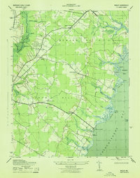
Greenbackville and Franklin City anchor the southeastern shoreline of this coastal landscape along Purnell Bay and Chincoteague Bay. This era of the Eastern Shore reveals a pattern of small agricultural and maritime settlements connected by a dense network of local roads and water-oriented landings. The proximity to the Pocomoke River and the presence of the Pocomoke State Frst in the northwest highlight the region's reliance on both timber and tidal waters.
Find a feature on this map
114 named features on this map. Tap any name to fly to it.
Don’t see what you’re looking for? This feature index may not catch every label — zoom into the map to look around manually.
Map Details
Editions of this 2011 Girdletree Map
This is the sole edition of this map. No revisions or reprints were ever made.
Other maps of this area

1901 · Snow Hill
USGS Topo · 1:62,500

1942 · Chincoteague East
USGS Topo · 1:24,000

1942 · Snow Hill
USGS Topo · 1:24,000

1942 · Wesley
USGS Topo · 1:24,000

1942 · Dividing Creek
USGS Topo · 1:24,000

1943 · Snow Hill
USGS Topo · 1:31,680

1943 · Boxiron
USGS Topo · 1:31,680

1943 · Dividing Creek
USGS Topo · 1:31,680
1943 · Wesley
USGS Topo · 1:31,680

1943 · Chincoteague West
USGS Topo · 1:31,680