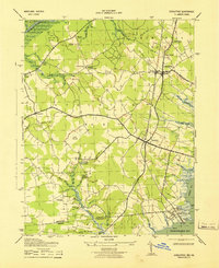
1943 Map of Girdletree
USGS Topo · Published 1943About this map
Girdletree and Stockton anchor this coastal plain landscape in the early 1940s, situated along the Pennsylvania railroad line. The map reveals an intricate network of drainage and agriculture, defined by features like Jones Ditch and Marshall Ditch which cut through the low-lying terrain toward the Chincoteague Bay. To the north, the Tarr State Game Refuge sits along the Pocomoke River, while the southern reaches show the tight-knit maritime settlements of Greenbackville and Franklin City at the Maryland-Virginia border. Local heritage is deeply etched into the geography through numerous rural landmarks, including the St Pauls School, Betheden Cem, and various houses of worship such as St Lukes Church and Remson Ch. The presence of Big Millpond and Little Millpond suggests the area's historical reliance on water-driven industry and milling.
Find a feature on this map
64 named features on this map. Tap any name to fly to it.
Don’t see what you’re looking for? This feature index may not catch every label — zoom into the map to look around manually.
Map Details
Editions of this 1943 Girdletree Map
This is the sole edition of this map. No revisions or reprints were ever made.
Other maps of this area

1901 · Snow Hill
USGS Topo · 1:62,500

1942 · Chincoteague East
USGS Topo · 1:24,000

1942 · Snow Hill
USGS Topo · 1:24,000

1942 · Wesley
USGS Topo · 1:24,000

1942 · Dividing Creek
USGS Topo · 1:24,000

1943 · Snow Hill
USGS Topo · 1:31,680

1943 · Boxiron
USGS Topo · 1:31,680

1943 · Dividing Creek
USGS Topo · 1:31,680
1943 · Wesley
USGS Topo · 1:31,680

1943 · Chincoteague West
USGS Topo · 1:31,680