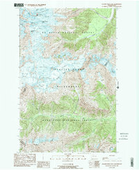
1988 Map of Glacier Peak East
USGS Topo · Published 1988About this map
Glacier Peak serves as the focal point for this late-twentieth-century study of the high Cascades, where the Glacier Peak Wilderness straddles the boundary between Snohomish and Chelan counties. The landscape is dominated by a complex system of ice and water, including the Suiattle Glacier, Honeycomb Glacier, and the White River Glacier. These frozen features feed several major drainage systems, notably the Suiattle River and White River, which carve deep valleys away from the volcanic center. The map captures the specialized topography of high-altitude features like Thunder Basin and North Guardian Rock. To the south, the terrain descends toward Airplane Lake and Mt Saul within the Wenatchee National Forest, illustrating the transition from glacial ice to high-alpine forest environments prior to the turn of the millennium.
Find a feature on this map
33 named features on this map. Tap any name to fly to it.
Don’t see what you’re looking for? This feature index may not catch every label — zoom into the map to look around manually.
Map Details
Editions of this 1988 Glacier Peak East Map
This is the sole edition of this map. No revisions or reprints were ever made.
Other maps of this area

1899 · Glacier Peak
USGS Topo · 1:125,000

1901 · Glacier Peak
USGS Topo · 1:125,000

1901 · Chiwaukum
USGS Topo · 1:125,000

1902 · Skykomish
USGS Topo · 1:125,000

1902 · Stehekin
USGS Topo · 1:125,000

1904 · Stehekin
USGS Topo · 1:125,000

1904 · Chiwaukum
USGS Topo · 1:125,000

1905 · Skykomish
USGS Topo · 1:125,000

1944 · Holden
USGS Topo · 1:62,500

1949 · Holden
USGS Topo · 1:62,500