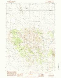
1983 Map of Glass Butte
USGS Topo · Published 1983About this map
The volcanic peaks of Glass Butte and Little Glass Butte dominate this High Desert landscape along the border of Deschutes and Lake counties. Published in the early 1980s, the map reveals a remote environment where survival depends on scattered water sources like Robins Spring, Chesbro Spring, and Cabin Spring. Infrastructure is sparse, marked by a Single Wood Pole Power Line and the prominent Glass Butte Radio Tower atop the summit. Evidence of ranching and land management appears in the form of the Musser Reservoir, Musser Well, and Musser Draw. To the north, the terrain flattens toward Dry Lake and Rattlesnake Ridge, where a Borrow Pit and various 4WD tracks represent the primary human modifications to this arid Oregon backcountry.
Find a feature on this map
21 named features on this map. Tap any name to fly to it.
Don’t see what you’re looking for? This feature index may not catch every label — zoom into the map to look around manually.
Map Details
Editions of this 1983 Glass Butte Map
This is the sole edition of this map. No revisions or reprints were ever made.
Other maps of this area

1955 · Crescent
USGS Topo · 1:250,000

1955 · Burns
USGS Topo · 1:250,000

1957 · Crescent
USGS Topo · 1:250,000

1958 · Crescent
USGS Topo · 1:250,000

1958 · Burns
USGS Topo · 1:250,000

1959 · Burns
USGS Topo · 1:250,000

1970 · Crescent
USGS Topo · 1:250,000

1980 · Round Top Butte
USGS Topo · 1:24,000

1981 · Hat Butte
USGS Topo · 1:24,000
1981 · Tired Horse Butte
USGS Topo · 1:24,000