
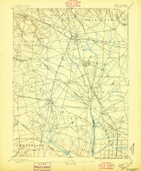
1890 Map of Glassboro
USGS Topo · Published 1890About this map
Glassboro and its surrounding townships in Gloucester and Salem Counties are depicted here at the height of their late-19th-century rail expansion. The landscape is defined by the strategic intersection of the Philadelphia and Reading Railroad and the West Jersey Railroad, which facilitated the growth of industrial and agricultural hubs like Clayton and Elmer. Local water power remains central to the economy, evidenced by family-named landmarks such as Ewan's Mills and Frie's Mill. The southern portion of the sheet reveals the headwaters of the Maurice River, winding through the townships of Franklin and Pittsgrove. Small settlements like Pitman Grove and Mullica Hill appear as established community centers, while numerous smaller crossroad hamlets like Five Points and Whig Lane illustrate the dense network of early South Jersey travel routes before the era of modern highways.
Find a feature on this map
76 named features on this map. Tap any name to fly to it.
Don’t see what you’re looking for? This feature index may not catch every label — zoom into the map to look around manually.
Map Details
Editions of this 1890 Glassboro Map
2 editions found
Other maps of this area

1888 · Mount Holly
USGS Topo · 1:62,500

1890 · Hammonton
USGS Topo · 1:62,500

1890 · Salem
USGS Topo · 1:62,500

1890 · Tuckahoe
USGS Topo · 1:62,500

1890 · Bay Side
USGS Topo · 1:62,500

1890 · Bridgeton
USGS Topo · 1:62,500

1891 · Philadelphia
USGS Topo · 1:62,500

1893 · Tuckahoe
USGS Topo · 1:62,500

1894 · Bay Side
USGS Topo · 1:62,500

1894 · Hammonton
USGS Topo · 1:62,500