1890 Map of Glassboro
USGS Topo · Published 1895About this map
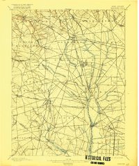
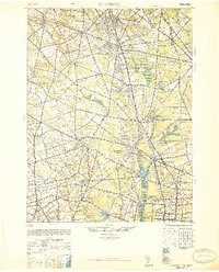
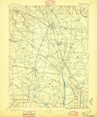
Glassboro serves as a major hub for South Jersey transportation during the late nineteenth century, where the Philadelphia and Reading Railroad and the West Jersey Railroad intersect. This 1890 survey illustrates the dense network of rail spurs and branches, such as the Williamstown Branch and Bridgeton Branch, which connected regional glassworks and agricultural centers to larger markets. Small settlements and industrial sites like Ewan Mills, Pitman Grove, and Frie Mill dot the landscape, often situated near vital water sources like Mantua Creek and Still Run. The map provides a clear look at the early division of townships, including Harrison, Clayton, and Franklin, during a period of steady transition from rural farming to a more connected industrial economy.
Find a feature on this map
84 named features on this map. Tap any name to fly to it.
Don’t see what you’re looking for? This feature index may not catch every label — zoom into the map to look around manually.
Map Details
Editions of this 1890 Glassboro Map
2 editions found

Historical Maps of Vineland Through Time
3 maps found