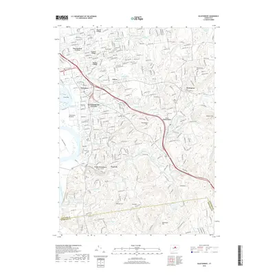
2018 Map of Glastonbury
USGS Topo · Published 2018About this map
The Connecticut River shoreline and the eastern uplands of Hartford County define this 2018 survey of the region. Glastonbury Center serves as the focal point, surrounded by residential clusters like Welles Village and East Hartford Gardens. The landscape transitions from the riparian Glastonbury Meadows to the prominent heights of Minnechaug Mtn and Kongscut Mtn. Traces of the area's development are evident in the path of the New London Tpke and the many named cemeteries, including the Old Church Cem and Saint James Cem, which offer significant value for genealogical research.
Find a feature on this map
79 named features on this map. Tap any name to fly to it.
Don’t see what you’re looking for? This feature index may not catch every label — zoom into the map to look around manually.
Map Details
Editions of this 2018 Glastonbury Map
This is the sole edition of this map. No revisions or reprints were ever made.
Other maps of this area

1892 · Hartford
USGS Topo · 1:62,500

1892 · Tolland
USGS Topo · 1:62,500

1892 · Gilead
USGS Topo · 1:62,500

1893 · Middletown
USGS Topo · 1:62,500

1906 · Farmington
USGS Topo · 1:125,000

1921 · Tolland
USGS Topo · 1:62,500

1928 · Cromwell
USGS Topo · 1:24,000

1928 · Windsor
USGS Topo · 1:24,000

1928 · Glastonbury
USGS Topo · 1:24,000

1928 · Manchester
USGS Topo · 1:24,000