
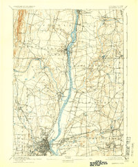
1892 Map of Hartford
USGS Topo · Published 1892About this map
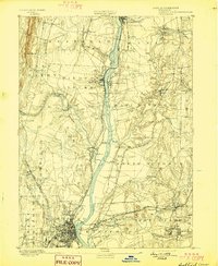
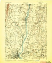
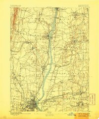
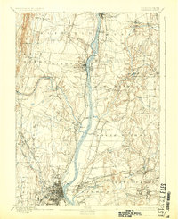
The Connecticut River bisects this late nineteenth-century landscape, serving as the central artery for a region defined by industrial growth and traditional river-valley settlement. The city of Hartford is meticulously detailed in the south, showing its dense urban grid and early rail infrastructure including the New York New Haven and Hartford Railroad. To the north, the geography is punctuated by manufacturing and transit hubs like Windsor Locks and Warehouse Point, where the river's descent necessitated complex engineering. Moving away from the main channel, the map reveals a network of smaller mill towns and farming hamlets such as Broad Brook, Hazardville, and Poquonock. Traditional river crossings are still vital to local movement, evidenced by the Bissel Ferry north of Windsor. These features, alongside family-named landmarks like Burnham and Sadds Mills, document a period when the river and emerging rail lines like the Hartford Division dictated the pace of Connecticut's commerce.
Find a feature on this map
68 named features on this map. Tap any name to fly to it.
Don’t see what you’re looking for? This feature index may not catch every label — zoom into the map to look around manually.
Map Details
Editions of this 1892 Hartford Map
8 editions found

Other maps of this area

1886 · Springfield
USGS Topo · 1:62,500

1887 · Palmer
USGS Topo · 1:62,500

1887 · Granville
USGS Topo · 1:62,500

1889 · Springfield
USGS Topo · 1:62,500

1889 · Palmer
USGS Topo · 1:62,500

1889 · Granville
USGS Topo · 1:62,500

1892 · Tolland
USGS Topo · 1:62,500

1892 · Meriden
USGS Topo · 1:62,500

1892 · Granby
USGS Topo · 1:62,500

1892 · Gilead
USGS Topo · 1:62,500