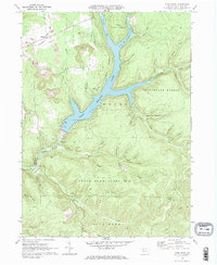
1969 Map of Glen Hazel
USGS Topo · Published 1972About this map
East Branch Clarion River Lake dominates the center of this 1969 topographic study, its blue waters filling the valleys between the deeply incised hollows of Elk State Forest. The map documents a landscape defined by industrial extraction and public recreation, where multiple Strip Mine symbols sit in close proximity to the State Game Lands No 25. Small settlements like Midmont and Rasselas are situated along the northwestern corridor, connected by the Baltimore and Ohio railroad and a network of pipelines. The terrain is remarkably intricate, named for the families and local features that defined its geography, such as Whittaker Hollow, Briggs Hollow, and Carlson Hollow. For researchers, the presence of the Holy Cross Cem and the detailed mapping of the Shawmut route provide essential points for tracing local history and land use patterns.
Find a feature on this map
47 named features on this map. Tap any name to fly to it.
Don’t see what you’re looking for? This feature index may not catch every label — zoom into the map to look around manually.
Map Details
Editions of this 1969 Glen Hazel Map
2 editions found
Other maps of this area

1935 · Mt. Jewett
USGS Topo · 1:48,000

1940 · Mt. Jewett
USGS Topo · 1:62,500

1941 · Benezette
USGS Topo · 1:62,500

1941 · Ridgway
USGS Topo · 1:62,500

1943 · Benezette
USGS Topo · 1:62,500

1944 · Ridgway
USGS Topo · 1:62,500

1948 · Crosby
USGS Topo · 1:62,500

1948 · Wildwood Fire Tower
USGS Topo · 1:24,000
1948 · Crosby
USGS Topo · 1:24,000
1950 · Wildwood Fire Tower
USGS Topo · 1:24,000
Featured Places
- Saint Marys, PA
- Jones Township, PA
- Glen Hazel, Jones Township
- Rasselas, Jones Township
- Streights, Jones Township