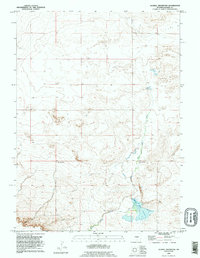
1990 Map of Glomill Reservoir
USGS Topo · Published 1995About this map
Goshen Hole Rim defines the topographic character of this southeastern Wyoming landscape, where the high plains drop away into the broad depression of the Goshen Hole. The 1990 revision, based on earlier imagery, shows a region defined by sparse ranching operations and carefully managed water resources. Cattle ranching is anchored at sites like Breckner Ranch and Teeters Ranch, which represent the enduring pastoral economy of the high desert. Drainage for the area is centered on Elder Box Creek, which flows southeast toward the Glomill Reservoir. This man-made water body serves as a critical focal point in an otherwise arid environment, illustrating the engineering required to sustain agricultural life on the Wyoming plains. The map provides a precise record of the section lines and township boundaries between Range 64 West and Range 65 West, essential for tracing land ownership in Goshen County.
Find a feature on this map
6 named features on this map. Tap any name to fly to it.
Don’t see what you’re looking for? This feature index may not catch every label — zoom into the map to look around manually.
Map Details
Editions of this 1990 Glomill Reservoir Map
This is the sole edition of this map. No revisions or reprints were ever made.
Other maps of this area

1896 · Patrick
USGS Topo · 1:125,000

1896 · Hartville
USGS Topo · 1:125,000

1899 · Goshen Hole
USGS Topo · 1:125,000

1901 · Hartville
USGS Topo · 1:125,000

1950 · Rockeagle
USGS Topo · 1:24,000

1951 · Eagles Nest
USGS Topo · 1:24,000

1954 · Torrington
USGS Topo · 1:250,000

1954 · Cheyenne
USGS Topo · 1:250,000

1958 · Cheyenne
USGS Topo · 1:250,000

1958 · Torrington
USGS Topo · 1:250,000